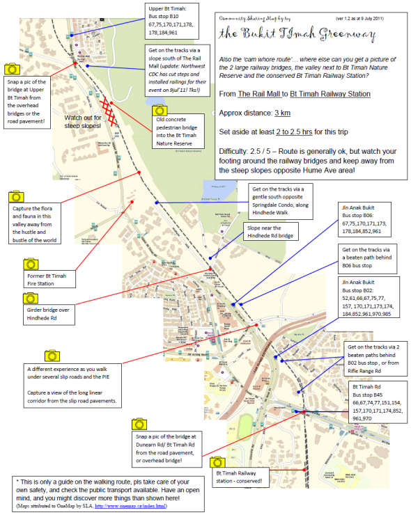
Walking route from Rail Mall to Bukit Timah Train Station
Here’s a map of the Bukit Timah Greenway – Walking route from Rail Mall to Bukit Timah Train Station, which includes good photo-taking spots. Thanks to the great effort from CY Leong!
Download high-res map of [download#8#size#nohits]
(Maps attributed to OneMap by SLA, http://www.onemap.sg/index.html)


It’s definitely necessary to leave some good old greenery (flora and fauna) for our future generation to enjoy. Efforts must be made by the people of Singapore to preserve what that is left and to bring the current government to its senses if it is going sacrifice it for economic gain.
yes, do share your ideas with URA at http://www.ura.gov.sg/railcorridor/share_idea.html
For this stretch, the walk should start hillview avenue where the Stanchart Bank is. The bus stop is in front of the bank and there is an excellent access point from back of the Bank.
You will then cross the concrete bridge over hill view avenue first and go along the sheltered area behind Summerhill towards the bridge at rail mall.
Sorry for the repeat, just wanted to make sure the info was on all the relevant maps.
Did a bit of walking around here recently, and found some good access points. My suggestions would be:
1: From Holland Road, take Bukit Sepdap Rd (opposite Jelita Cold Storage). Just before the first house ont eh left, there’s a path down the side. This path goes down to the level of the railway and provide easy access for walkers and bikers.
2: At Bukit Timah Road, take Rifle Range Road which runs parallel to the railway at the same level for 500m or so. Plenty of access easy points for bikes and walkers.
3: Just south of Rail Mall, there are two access points. One is steep and next to the side of the bridge over Upper Bukit Timah road, and has a concrete ramp and then a short scramble over stones by the tracks. The second option is easier but more muddy, about 50m further south as you follow the tracks.
4: At Hillview Road, the bridge over the road is no longer there. I’ve only accessed the southern part of the track, the best is to one side (nearer Hillview Ave rather than Upp Bk Timah Rd) where a short mud slope gives you easy access.
I will explore more and head north from Hillview Road soon!
We are interested to explore one of the route – The Rail Mall to Bt Timah Railway Station. Not sure this route still accessible? As the information that you collated was in 2011. Kindly advice. Thï½ï½Žï½‹ã€€ï½™ï½ï½•ï¼ã€€ã€€ï¼¡ï½—ï½ï½‰ï½”ing fï½ï½’ yï½ï½•ï½’ fï½ï½–ï½ï½•ï½’ï½ï½‚le reï½ï½Œï½™ã€€ï½“ï½ï½ï½Žï¼Ž
I ran from Rail Mall to Buona Vista today, about 6km. It was beautiful, and very easy thanks to the new Downtown MRT line. I took Downtown MRT to Hillview, walked towards and past Rail Mall and then went up the little hill to the left of the railway bridge crossing the road. You can’t miss the bridge, and the access is perfect–nice and easy. From Hillview to the bridge is about 350 or 400 meters. You could park at the Rail Mall if you wanted to as well. Then I exited the corridor at Buona Vista where the Circle Line and East West MRT lines are conveniently located. So there you have it–easy access, one way with MRT stations at both ends, and parking. The exit up to the MRT is on the right side after you go under the bridge for N. Buona Vista Road.
I’m just a tourist but I appreciate this website for helping me find this beautiful place to run and thought I would give something back. Cheers!
Dear Sir / Madam
A group of Senior Citizens would like to visit the Green Corridor in December 2016. Our friends highlighted to us that somewhere near Hillview area before railway mall at night when the whole place turns dark, we can see firefly which a good experience.
Please advise us how we reach that place near Hillview area.
Thank you
Lim Chwee Teck
hp. 90928611
Hi
Very good route and only problem is coming out from this corridor and connect to pcn is very steep.
In alexdandra bridge coming out from this route to above route no connection and man made slope is very slope and dangerous to pull cycles from below to above.
please make so slope path so that we can commute with safe.
thanks
Vijay