
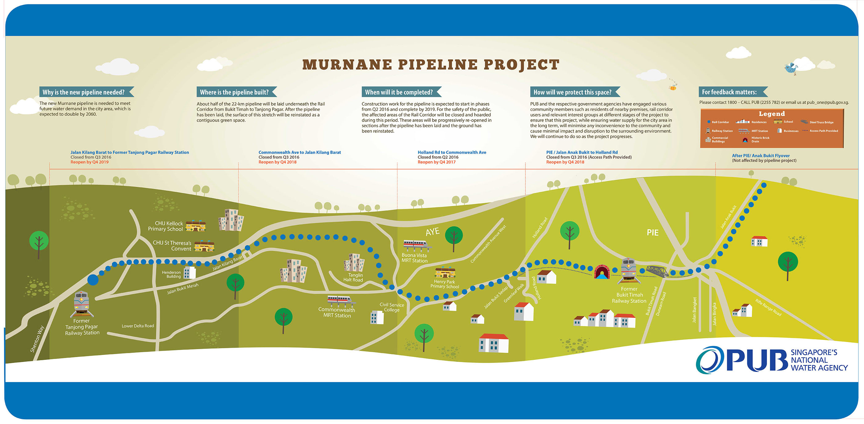
Murnane Pipeline Project
Note from PUB on the Murnane Pipeline Project
PUB will be commencing work for the laying of a new water pipeline in Q2 2016. Half of the pipeline will run beneath the Rail Corridor. The works will be carried out in phases and is expected to complete by 2019. For public safety, PUB will temporarily close off the stretch of the Rail Corridor south of Holland Road during this period, and progressively reopen sections from 4Q2017 after the pipeline has been laid and the ground reinstated. The rest of the Rail Corridor will remain open to the public.
PUB’s Facebook page will provide updates on the Murnane Pipeline Project.
Pls click to view the project information map (updated on 7 Jun 2016).
Overview Map of Railway
Over the past few days, we posted 8 maps of walking routes for:
- Sungei Kadut Avenue to Woodlands Road
- Sungei Kadut Avenue to Choa Chu Kang Road
- Choa Chu Kang Road to Rail Mall
- Rail Mall to Bukit Timah Train Station
- Bukit Timah Train Station to Holland Road
- Holland Road to Buona Vista
- Buona Vista to Queensway Road
- Jalan Hang Jebat to Kampong Bahru
We will not be organising walks but hope that you can use the maps to explore The Green Corridor on your own or with your family and friends. Enjoy!
Here’s an overview map of the entire railway from Tanjong Pagar to Woodlands, thanks again to the excellent efforts of CY Leong.
Download high-res map of [download#6#size#nohits]
")
(Maps attributed to OneMap by SLA, http://www.onemap.sg/index.html)
Walking route from Choa Chu Kang Road to Rail Mall
Here’s a map of A Rail Ran Through It – Walking route from Choa Chu Kang Road to Rail Mall, which includes good photo-taking spots. Thanks to the great effort from CY Leong!
Download high-res map of [download#10#size#nohits]

(Maps attributed to OneMap by SLA, http://www.onemap.sg/index.html)
Walking route from Sungei Kadut Avenue to Woodlands Road
Here’s a map of the The Northern Outreaches – Walking route from Sungei Kadut Avenue to Woodlands Road, which includes good photo-taking spots. Thanks to the great effort from CY Leong!
Download high-res map of [download#9#size#nohits]


(Maps attributed to OneMap by SLA, http://www.onemap.sg/index.html)
Walking route from Jalan Hang Jebat to Kampong Bahru
Here’s a map of AYE’s Biological Twin – Walking route from Jalan Hang Jebat to Kampong Bahru, which includes good photo-taking spots. Thanks to the great effort from CY Leong!
Download high-res map of [download#7#size#nohits]


(Maps attributed to OneMap by SLA, http://www.onemap.sg/index.html)
Walking route from Bukit Timah Train Station to Holland Road
Here’s a map of One Walk for All – Walking route from Bukit Timah Train Station to Holland Road, which includes good photo-taking spots. Thanks to the great effort from CY Leong!
Download high-res map of [download#5#size#nohits]
")
(Maps attributed to OneMap by SLA, http://www.onemap.sg/index.html)
Walking route from Holland Road to Buona Vista
Here’s a map of Our Hidden Backyard – Walking route from Holland Road to Buona Vista, which includes good photo-taking spots. Thanks to the great effort from CY Leong!
Download high-res map of [download#4#size#nohits]
")
(Maps attributed to OneMap by SLA, http://www.onemap.sg/index.html)
Walking route from Buona Vista to Queensway Road
Here’s a map of Rojak of Old and New – Walking route from Buona Vista to Queensway Road, which includes good photo-taking spots. Thanks to the great effort from CY Leong!
Download high-res map of [download#3#size#nohits]

(Maps attributed to OneMap by SLA, http://www.onemap.sg/index.html)
Walking route from Sungei Kadut Avenue to Choa Chu Kang Road
Here’s a map of A Walk by the Sungei – Walking route from Sungei Kadut Avenue to Choa Chu Kang Road, which includes good photo-taking spots. Thanks to the great effort from CY Leong!
Download high-res map of [download#2#size#nohits]


(Maps attributed to OneMap by SLA, http://www.onemap.sg/index.html)
Walking route from Rail Mall to Bukit Timah Train Station
Here’s a map of the Bukit Timah Greenway – Walking route from Rail Mall to Bukit Timah Train Station, which includes good photo-taking spots. Thanks to the great effort from CY Leong!
Download high-res map of [download#8#size#nohits]
")
(Maps attributed to OneMap by SLA, http://www.onemap.sg/index.html)