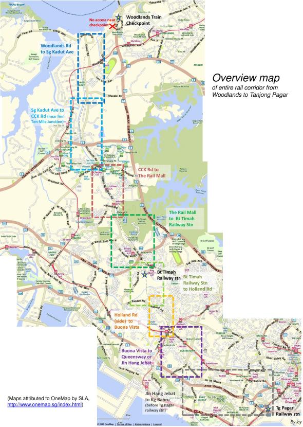
Overview Map of Railway
Over the past few days, we posted 8 maps of walking routes for:
- Sungei Kadut Avenue to Woodlands Road
- Sungei Kadut Avenue to Choa Chu Kang Road
- Choa Chu Kang Road to Rail Mall
- Rail Mall to Bukit Timah Train Station
- Bukit Timah Train Station to Holland Road
- Holland Road to Buona Vista
- Buona Vista to Queensway Road
- Jalan Hang Jebat to Kampong Bahru
We will not be organising walks but hope that you can use the maps to explore The Green Corridor on your own or with your family and friends. Enjoy!
Here’s an overview map of the entire railway from Tanjong Pagar to Woodlands, thanks again to the excellent efforts of CY Leong.
Download high-res map of [download#6#size#nohits]
(Maps attributed to OneMap by SLA, http://www.onemap.sg/index.html)


I would like to send my greatest appreciation to C Y Leong for producing the 8 maps on The Green Corridor website. I have printed out every one and have covered 5 of them, with one more still to go – Rail Mall to Bt Timah which is open a bit longer. I have read all the side bits of information and they have made the walk even more enjoyable. I would like to make a suggestion (Buona Vista to Queensway map) re the abandoned building near Buona Vista Drive. An old map of Singapore I have from England shows a branch line going off just about here which I have called the “Portsdown Line.” It extends almost to the present AYE and I think this could have been used by army personnel in the days when British officers lived in this area. It clearly looks like a small station from the other side, with a canopy and a platform. The line would have run through the Wessex Estate up to maybe what is now the Tanglin Trust School off Portsdown Road, but a lot of the route would now be under the One North development.
Hi Barbara, you’re right about the military line. It was one of a few military railways in Singapore.
http://searail.mymalaya.com/Singapore/Military.htm
“Two of these branched off the main line between Tanjong Pagar and Tanglin Halt, the exchange sidings for the latter being adjacent to Tanglin halt. These were served by two Avonside Engine Company 0-6-0STs, SL7 (yard No 144) and SL8 (yard No 145), and a Bagnall 0-4-0ST 2770 of 4/1944, yard No 1729. Whenever these locomotives moved between depots they had to use the main line and a token had to be obtained from either Tanjong Pagar or Bukit Timah and returned promptly by road after the movement. A third line branched off south of Bukit Timah, near my old home at Jalan Jelita, ran westwards, then turned north and crossed Ulu Pandan Road and entered a depot at Buona Vista Battery (see map on Singapore Railway history page). There was a fourth siding to the ammunition depot at Kranji, closed in 1959 – I am not sure if this is the same siding which later served a Shell depot at Kranji. The line from Tanglin exchange sidings ran south and then west, crossing Portsdown road near a school and ending up in the military complex adjacent to Ayer Rajah road near the junctions with North and South Buona Vista roads.”
To contribute to users of the Green Corridor, I’ve created this Google Map that allows people to zoom in and easily plan how to access and exit.
http://goo.gl/maps/999MQ
All feedback is welcome.
Hi Thomas
Great work! Very helpful
We recently opened Byx. a bike shop at BT nature reserve just a step from the green corridor descent to Hindhede rd. Would be great if you add our spot as a meeting point, service station for bikes, bike parking and a refreshment station for riders using the green corridor.
I would like to recommend this Google map of the corridor: https://maps.google.com/maps/ms?msid=203657728530647991491.0004d5871661a588db687&msa=0
It shows easy access points, crossings with park connectors and obstacles along the way. It’s frequently updated by an avid user of the corridor.